The urban frontier lies not in greenfield oases but on the edges of today’s cities. Directing capital to make urban peripheries more resilient can simultaneously confront the challenges of climate and affordability.
The new city mirage
The next cities will not be founded – they will be extended. Almost all urban growth between now and 2050 will take place on the edges of cities that already exist.
Saudi Arabia announced The Line in 2021 as a 170 km city for 9 million people. In September 2025, its Public Investment Fund (PIF) suspended construction, with barely 2.4 km of foundation work completed and no permanent residents. Similarly, Indonesia built a new capital from scratch – Nusantara – but today it houses only 10,000 residents, and its budget was slashed from $2.7 billion in 2024 to $350 million in 2026.
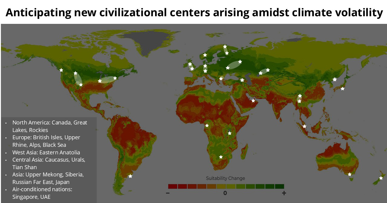
Marquee greenfield projects are little more than rounding errors in the grand story of urbanization. The real story all along has been the expansion of today’s key metropolis hubs. Shenzhen and Dubai started small in the 1970s, but the combination of propitious geography for trade, special jurisdictional status, and immense investment in functional infrastructure made them the fastest growing cities in world history.
All growth is urban: From 12,000 to 15,000 cities
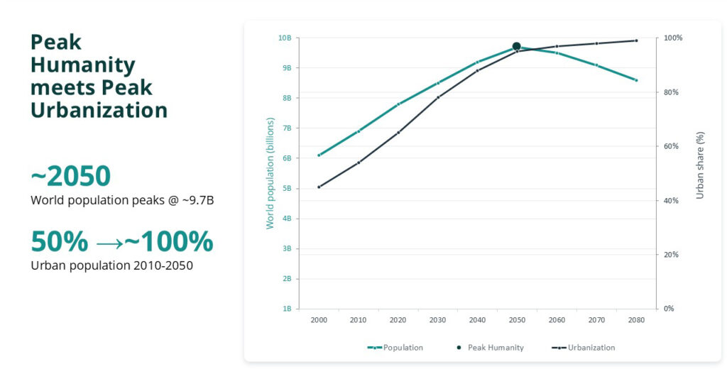
In the mid-2000s, the United Nations announced that the global urban population had crossed fifty percent, with towns and rural areas dividing the remainder. Since that time, the urbanization rate has only accelerated: each year, roughly one percent of the world population moves into cities, resulting in an urbanization rate nearing 75 percent today. Every additional human being between now and mid-century is, on balance, an urban dweller.
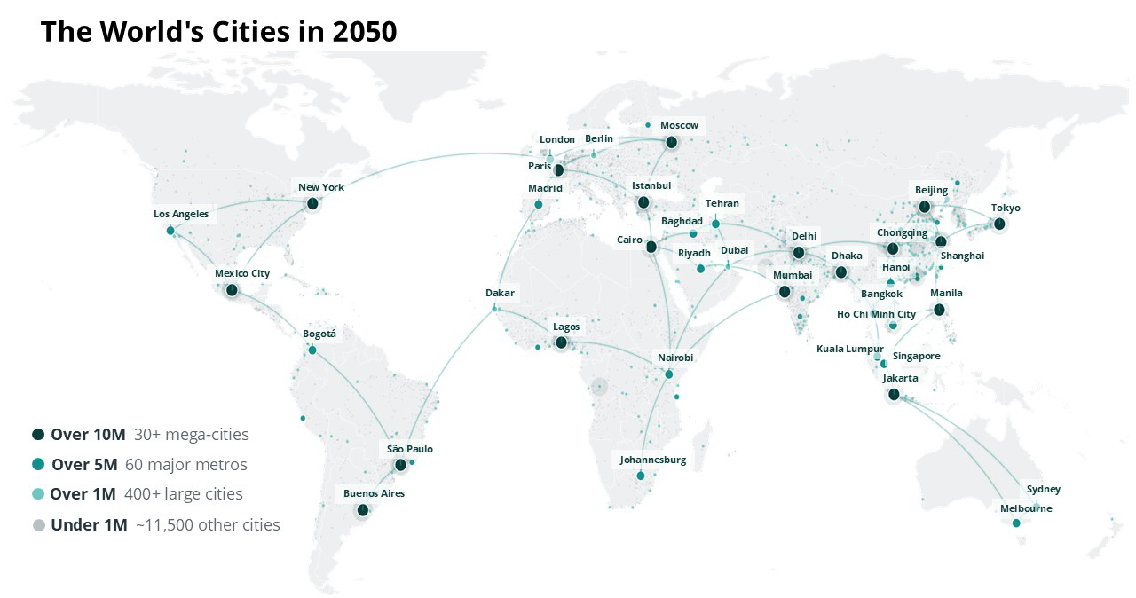
The urban growth of today and tomorrow is unfolding in plain sight. Megacities of 10 million or more quadrupled from 8 in 1975 to 33 in 2025, with over half in Asia, led by Jakarta and Dhaka. Seven countries absorb the bulk of urban expansion: India, Nigeria, Pakistan, Congo (Kinshasa), Egypt, Bangladesh, and Ethiopia. The fastest urban growth on Earth is therefore the overflow of the very cities that are already some of the most populous in the world.
The roughly 12,000 cities in the world today are already double the number from 1975, using the threshold of 50,000 people at urban density. By 2050, that number could reach 15,000, with most of them under 250,000 people. The 3,000 additions are not greenfield projects but today’s towns unceremoniously growing into the definition.
Peak humanity changes the arithmetic
At the same time, global fertility is collapsing and “peak humanity” is around the corner. The world population by 2050 could level off at just 9.5 billion, after which it may precipitously decline. Given present urbanization rates, by that point in time, almost the entire world population could be settled in cities and towns.
Once global population plateaus, however, urban growth stops being additive and becomes redistributive. One city’s gain is another city’s decline. Choosing a location stops being a bet on growth and becomes a bet against the city next door. Indeed, though most cities are expanding, thousands are already shrinking – almost all of them under 250,000 people. Until now, allocators asked which cities will grow. After peak humanity, the question becomes: which cities will hold what they have?
So where should the next cities be?
We should approach the question as an underwriter would: Which sites will still be solvent in 2050 and beyond? Six screens decide it, all of which are measurable today:
- Water. Drought exposure through 2050 and 2100, set against water works, water storage, and groundwater access. Water is the constraint that kills a site before construction starts.
- Heat. Heat stress on buildings, productivity, and thermal comfort, adjusted for building density and urban greenery. A city planned at today’s wet-bulb temperatures is operating in the wrong century.
- Flooding. Inland and coastal flood exposure measured against surface porosity, drainage, barriers, and nature-based defenses. Most edge growth today fails this test.
- Power. Total power plant capacity within a 50 km radius, electricity access, and renewables share. Grid capacity now competes directly with data center demand for the same sites, meaning power demand should not be underestimated.
- Labor and connectivity. Working-age population share, educational attainment, infrastructure quality, and air connectivity. A city with no labor catchment remains a real estate project.
- Governance and capital. Government effectiveness, political stability, foreign direct investment, and sovereign credit. These determine whether capital outlays get funded after the ribbon is cut.
Running these screens across the global urban landscape leads us to the high-conviction urban landscapes that already boast labor markets, a water supply, and a robust grid. Mostly, the next cities belong beside the old ones. Expansion, satellite districts, and secondary cities absorb growth at a fraction of the capital cost, and the demographic data says people are already moving there without being asked.
Sprawl is the real megaproject
As the filters above suggest, however, urban expansion carries real risk when built on floodplains, coastal margins, and drought-exposed peripheries – especially in municipalities with the thinnest adaptation budgets. Resilience will therefore decide which cities keep their people and which lose them. As AlphaGeo has documented in its research on 72 of the largest cities in the world, many of the same Asian and African megacities experiencing the fastest growth face the steepest damage curves from climate hazards.
Here’s how AlphaGeo guides investors in committing capital behind resilient locations:
- Resilience-adjusted risk: The Climate Risk and Resilience Index (CRRI) scores 9 acute and chronic hazards at asset-level resolution, down to 5–10 meters, for every decade to 2100. It reports both physical risk and resilience-adjusted risk, so two sites with identical hazard exposure are never mistaken for identical investments.
- Adaptation capacity: The Global Adaptation Layer is the world’s first commercially available, multi-hazard database on global adaptation capacity. It captures the engineered and nature-based measures in place across nine hazards, from drainage and flood barriers to coastal defenses and urban greenery.
- Macro Suite: Global Dynamism Signals consolidates more than 100 curated macro indicators across more than a dozen themes, geospatially downscaled, spanning demographics, infrastructure, energy, governance, migration, and livability. Clima-Metrics translates hazard intensity into subnational GDP loss by sector, in both unadapted and resilience-adjusted form.
- Siting decisions: Alpha Finder runs the screens end-to-end for a customized brief specific to each client’s requirements, executed by domain expert agents, and verified by our team before it ships as a ranked shortlist.
Governments face the same calculation with the stakes reversed. Adaptation used to be a cost line. It is becoming a competitive position. Drainage, power and water are now part of what a state offers investors and residents against the country next door. Chicago ranks where it does on a temperate climate plus decades of flood-mitigation spending, including its underground tunnel and reservoir system.
We already know where the next 25 years of urban growth will happen: At the edges of cities that exist today, in countries with the least money to spend on adaptation, and on land nobody has priced for the climate it will face. Build there with intelligence – or pay for it later.